Prime2 Fixes
This page details the manual fixes carried out by Compass Informatics to add in edges missing in Prime2, but present in the old MapRoad road schedules, and work splitting Prime2 edges into public and private roads based on the MapRoad road schedules.
Missing Edges
Over 1700 edges from MapRoad were added back to the road schedules, using MapRoad geometries. This represents 228 Km of road surface.
Notes
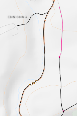
No splitting an existing edge twice e.g.
Make sure the red line does not overlap the black (existing) network
The red line can only split a black line once
Snap to nodes where possible (don’t cut an existing edge 1m from a junction for example). No need to enter NodeIds unless snapping to an existing (black) node. Any “orphaned” red lines don’t need any NodeIds.
A black line can currently only be cut by a single missing edge (can’t add 2 edges to same black line creating multiple splits)
If existing Prime2 geometry exists under the line the LA can add this themselves
Add start and end edge IDs of existing geometries to join to. Arrow directions can help with this.
When an existing edge is cut by 2 edges to be added, one of the edges needs to be ignored. The following criteria can be used:
Minimise duplicates (if commenting out 1 record means 2 others can be added do this)
Minimise cuts - ideally we don’t want to split the network, so pick an edge that cuts at one end not both
Use more important segment code - L-5683-5 is a higher road class than L-56832-5
Longest lengths - as shown in image
Lower seg code - use -1 rather than -2
Public Private Splits
Over 2,800 roads server split, with ~640 Km of roads marked as private. See the Public and Private Roads page for details on how it was decided which roads were split.
Notes
If a whole edge can be removed it can be ignored