PMS 6.1 Release Notes
Development for PMS 6.1 began towards the end of February 2023 and ran for 26 weeks. It was comprised on 13 sprints, the sprints were named after films.
Dynamic Routing
Under 6.0 we gave users the tools to digitise a “user-entered” network of edges, predominately to allow for the capture of Active Travel Infrastructure (ATI). While edges in the user-entered network could spatially snap to the main PRIME2 network, the level of connectivity did not allow for routing between the networks. Meaning, at the level of surveys and project works, the two networks remained functionally separate entities.
The question and challenge poised by the 6.1 development was: how can we create route-able connection points (network nodes) at the intersections of the user-entered network and the PRIME2 network, without breaking (i.e. 1 edge becomes 2+ edges) the PRIME2 network at these nodes?
The solution was Dynamic Routing. Simply put, this is the process whereby nodes are stored as measures along the PRIME2 network, where these measures are used to dynamically split the network as part of the routing request, leaving the PRIME2 network in tact, and mitigating the complications that would necessarily come with PRIME2 updates.
With dynamic routing in place, PMS users can now create surveys and project works that are comprised of both user-entered and PRIME2 network edges. Potentially a real game changer for Local Authorities.
NTA & TII User Privileges
New Survey Modules
PSCI Browser Module
A Pavement Surface Condition Index (PSCI) mobile app has existed for some time. For PMS 6.1 we developed a complimentary PSCI survey module for the web browser application. The module consists of a new data entry form that fits the standard model of survey forms in the PMS. This will allow users in the Roads Management Office (RMO) to apply PSCI ratings to sections of the Road Schedule where the data has been gathered from sources other than the mobile app.
Width Survey Module
A new segment Width survey module has also been developed for user to select a stretch along the road network and apply a width value. The values added via the width module are automatically aggregated for segments, where each segment form displays these values.
Latest Width Surveys: When multiple surveys overlay, timestamps are used to calculate the latest and display this only. Sections of the road network that have never been surveyed are also shown.
Width Survey Edges: All surveyed edges.
Width Surveys: Full survey geometries.
Module Enhancements
Segments
Abandon a Public-road. In this case the road become Non-public.
Extinguish a Public Right of Way (making it private).
Where the type of way is Agreed Consent to Access, users can now cease the agreement and return the road to private ownership.

Missing Edges

Projects
Public Lighting Reference Layers
Tech Refresh
Python 2->3
The PMS relies on several Python libraries for routing, spatial data exports, and printing. These had all been written using Python 2.7 which had an End of Life (sunset date) of 2020.
As a part of the 6.1 release, we ported all the Compass PMS Python libraries and their dependencies to Python3, and removed Python2 from the backend server.
Upgrade of Mobile Apps to target later Android Versions
PSCI
Speed Limits
Footways
Bridges
Projects (Works)
Sprints, Tasks & Bugs
| # | Sprint Dates | Sprint Name | Notes |
|---|---|---|---|
| 1 | 27st Feb - 10th March | Eraserhead | Core Development |
| 2 | 13 March - 24th March | Funny Games | Core Development |
| 3 | 27th March - 7th April | Goodfellas | Core Development |
| 4 | 27th March - 7th April | High Fidelity | Core Development |
| 5 | 10th April - 21st April | I, Robot | Core Development |
| 6 | 8th May - 19th May | Jaws 2 | Deployed #2.8 NTA & TII User Privileges to Production |
| 7 | 22nd May - 2nd June | Kindergarten Cop | Core Development |
| 8 | 5th June - 16th June | Léon | Core Development |
| 9 | 19th June - 30th June | Midnight Run | Core Development |
| 10 | 3rd July - 14th July | Night of the Living Dead | Core Development Testing |
| 11 | 17th July - 28th July | One Flew Over the Cuckoo's Nest | UAT |
| 12 | 31st July - 11th Aug | Point Break | Regression Testing |
| 13 | 14th Aug - 25th Aug | Quadrophina | Deployment to Production |
| Work Item Type | Epic Title | Feature Title | User Story Title | Task/Bug Title |
|---|---|---|---|---|
| Epic | PMS 6.1 | |||
| Feature | 6.1 Inventory | |||
| User Story | #1.1 Network Edge & Node Import Automation | |||
| Bug | Line tool will not find the feature if a specific route is made | |||
| Bug | ImportNetworkEdgesAndMissingEdges is creating errors | |||
| Task | Merge EdgeIds and measures back together in solver results | |||
| Task | Get missing edges and split existing edges in network pickle files | |||
| Task | Update JS project to allow non exact coords in Info Tool | |||
| Task | Test 1.1 Network Edge & Node Import Automation | |||
| Task | Get PMS database backup to review new Missing Edges | |||
| Task | Check Missing Edge tool cannot connect to Processed missing edges | |||
| Task | Update MapServer classes to show connected/unconnected | |||
| User Story | #1.3a Survey Modules: ATI Name (greenways) | |||
| Bug | Schedule data grid - Group Edit button is missing making it impossible to select the column to edit | |||
| Task | UI: Remove Green Route from the Legacy Values tab. | |||
| Task | Test 1.3a Survey Modules: ATI Name (greenways) | |||
| Task | Update RS grid docs page | |||
| Task | JS: Make RoadScheduleGrid.js an editable table | |||
| Task | DB: IsGreenRoute to IsGreenway | |||
| Task | .NET: Create service | |||
| User Story | #1.3b Survey Modules: Width | |||
| Bug | Width Survey date not being saved/returned correctly | |||
| Bug | History Tab not Recording Increments when Being Edited | |||
| Bug | Average Width column not included in the Road Schedule | |||
| Bug | Not Surveyed Style not being displayed for Width Surveys | |||
| Bug | Not Surveyed Style not being displayed for Width Survey Edges | |||
| Bug | Latest Width Grid - Survey Date not displaying correctly on the exported File, Has Survey displaying Flag Value Rather than Yes/No | |||
| Bug | Width Survey 'Width' only accepting whole numbers | |||
| Bug | Entries with 'Width' = 1 being displayed in the Less than 1 width range | |||
| Bug | Width Survey Edges - Survey Date not displaying correctly on the exported File, Has Survey displaying Flag Value Rather than Yes/No | |||
| Bug | Width Surveys - Legend Not lining Up to Width Info | |||
| Bug | Select by Shape not working for 'Width Survey Edges' | |||
| Bug | Styling Issue for Width Survey Edges | |||
| Task | Create Documentation | |||
| Task | Services: GET/POST/PUT/DELETE /width/Survey | |||
| Task | DB: Create schema width | |||
| Task | DB: Create table width.WidthSurveys | |||
| Task | DB: Create table width.WidthSurveyEdges | |||
| Task | DB: Create table report.WidthSummary | |||
| Task | DB: Create procedure report.UpdateWidthSummary | |||
| Task | Map: Create 'Latest Width Surveys' layer | |||
| Task | Map: Create 'Width Surveys' layer | |||
| Task | UI: Create menu items under Surveys dropdown | |||
| Task | UI: Create 'Add Width Survey' form | |||
| Task | JS: Create 'Latest Width Surveys' grid | |||
| Task | JS: Create 'Width Surveys' grid | |||
| Task | UI: Add Width Tab to Info Tool | |||
| Task | Services: Add Width to Info Tool Services | |||
| Task | Test 1.3b Survey Modules: Width | |||
| User Story | #1.3c Survey Modules: PSCI | |||
| Bug | Missing Columns in Grid | |||
| Task | PY: Update grid templates to include PSCI in getID | |||
| Task | Docs: Help Page | |||
| Task | UI: Create menu items | |||
| Task | UI: Surveyor search | |||
| Task | .NET: Update/Migrate POST | |||
| Task | .NET: Create GET PSCI survey service (with history property) | |||
| Task | .NET: Create GET service to return user name | |||
| Task | .NET: Create PUT PSCI survey service | |||
| Task | .NET: Create DELETE PSCI survey service | |||
| Task | .NET: Create Attachment services | |||
| Task | DB: Convert Status and Compliance calculations into functions | |||
| Task | DB: update Mapserver_vw_PSCISurveyLatest.sql to use new function | |||
| Task | Add Licensing Area and Usage Classification properties to segments feature collection for all surveys | |||
| Task | UI: Create form | |||
| Task | Test 1.3c Survey Modules: PSCI | |||
| User Story | #1.5 Public Lighting Reference Layers | |||
| Bug | Layer tree - Lights data grid is missing some columns | |||
| Bug | Layer tree - Service Pillars data grid is missing some columns | |||
| Task | Test 1.5 Public Lighting Reference Layers | |||
| Task | Create lights vector map layer | |||
| Task | Create pillars vector map layer | |||
| Task | Create lights layer grid | |||
| Task | Create pillars layer grid | |||
| Task | Create Lights MS View | |||
| Task | Create Pillars MS View | |||
| Task | Create PMS docs page | |||
| User Story | #1.2 PRIME2 Vector Layer | |||
| Bug | Error when group editing To Be Imported? value | |||
| Task | Create doc page | |||
| Task | MapServer view | |||
| Task | MapServer layer/SLD/Grid | |||
| Task | Editable grid | |||
| Task | SQL to import and assign LA | |||
| Task | Create Deployment Script | |||
| Task | Create grid update service | |||
| Task | DB: Add to ImportToMissingEdges | |||
| Task | Test 1.2 PRIME2 Vector Layer | |||
| Task | Missing Edge Class for imported edges | |||
| User Story | #1.4b Road Schedule - History tab | |||
| Bug | Can't edit Segments because Segment ID is not working properly | |||
| Task | .NET: update history object in GET /roadschedule/segment/{segmentId} response with new values | |||
| Task | Test 1.4b Road Schedule - History tab | |||
| Task | UI: Update history grid to show new values returned | |||
| Task | Update Segments_HistoryTab.rst docs | |||
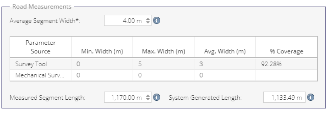
| User Story | #1.7 Segment Form Measurements Panel | |||
| Bug | Possible to Save with Average Width=Null | |||
| Task | Test 1.7 Segment Form Measurements Panel | |||
| Task | UI: Update the Measurements panel of the Segment form to display new data | |||
| Task | Mapping: Add Segment level width values to the Road Schedule grid | |||
| Task | UI: Further UI changes | |||
| Task | Modify GetSegment service to return Min, Max and Average Road Width from Width Survey Module | |||
| Task | Modify GetSegment service to return Min, Max and Average Road Width from Road Width Mechanical Survey | |||
| Task | Replace MinWidth & MaxWidth with Average Width in roadschedule.Segments | |||
| Task | Update Segment Form documentation | |||
| User Story | #1.8 ATI Features Footways Offset | |||
| Task | Test 1.8 ATI Features Footways Offset | |||
| Task | FE: Update ATI Features functionality to allow offsets from Footway segments | |||
| Task | Update map Layers | |||
| Task | BE: Ensure correct values are sent and received | |||
| Task | BE: Remove 'Combined Footway Cycle Track' usage classification and project type | |||
| User Story | #1.4a Road Schedule processes (abandoned, extinguished, agreed consent to access) | |||
| Bug | Classification not being displayed for in the Segments Form | |||
| Bug | Date of Agreement' is saved after 'Type of Way' Changed to value different than 'Agreed Consent to Access' | |||
| Bug | Validation for Date of Agreement not letting user Save | |||
| Bug | Can't extinguish Segment Marked as 'Motorway' | |||
| Bug | Can't set 'Motorway' as abandoned | |||
| Bug | Form will partially hide 'Schemes' and 'Schedule Criteria' after Saving | |||
| Bug | Form will display double Usage Classification if marked as 'Protected' or 'Busway' | |||
| Task | UI: Add in new panel and checkboxes for new values | |||
| Task | UI: Move the Location Panel to its own tab (and update save messages to reflect) | |||
| Task | .NET: Update segment validation logic for IsExtinguished and IsAbandoned | |||
| Task | .NET: Update segment validation logic for Agreed Consent to Access | |||
| Task | DB: Add IsExtinguished and IsAbandoned boolean values to roadschedule.Segments. | |||
| Task | DB: Add IsExtinguished and IsAbandoned values to procedures | |||
| Task | DB: Add IsAgreementCeased boolean value to roadschedule.Segments. | |||
| Task | DB: Add IsAgreementCeased to procedures | |||
| Task | DB: Add AgreedConsenttoAccessDate timestamp value to roadschedule.Segments | |||
| Task | when a road is abandoned it should no longer be included in the schedule | |||
| Task | Mapping: Add new style for segment states | |||
| Task | Frontend: Update Segment form business logic for IsExtinguished | |||
| Task | Frontend: Update Segment form business logic for IsAbandoned | |||
| Task | Frontend: Apply new form logic for Agreed Consent to Access | |||
| Task | DB: Update MapServer views with new values | |||
| Task | Test 1.4a Road Schedule processes (abandoned, extinguished, agreed consent to access) | |||
| Task | Update RS docs | |||
| User Story | #1.0 Review of Existing Missing Edges & Appraise and update how Network Edges are categorised in the PMS DB | |||
| Task | Define Process | |||
| Task | Carlow | |||
| Task | Cavan | |||
| Task | Clare | |||
| Task | Cork City | |||
| Task | Cork County | |||
| Task | Donegal | |||
| Task | Dublin | |||
| Task | Dun Laoghaire | |||
| Task | Fingal | |||
| Task | Galway City | |||
| Task | Galway | |||
| Task | Kerry | |||
| Task | Kildare | |||
| Task | Killkenny | |||
| Task | Laois | |||
| Task | Leitrim | |||
| Task | Limerick | |||
| Task | Longford | |||
| Task | Louth | |||
| Task | Mayo | |||
| Task | Meath | |||
| Task | Monaghan | |||
| Task | Offaly | |||
| Task | Roscommon | |||
| Task | Sligo | |||
| Task | South Dublin | |||
| Task | Tipperary | |||
| Task | Waterford | |||
| Task | Westmeath | |||
| Task | Wexford | |||
| Task | Wicklow | |||
| Task | MapServer: Update Edges connectivity style to include 'Road Schedule (unsnapped)' | |||
| Task | MapServer: Update Nodes connectivity style to include 'Road Schedule (unsnapped)' | |||
| Task | MapServer: Update nodes styles to include "Dynamic" connectivity | |||
| Task | MapServer: Update edge styles to include "Dynamic" connectivity | |||
| Task | PY: Running snapping script | |||
| Task | DB: SQL to 'Markfordeletion' all unregistered/not snapped missing edges (created pre 6.0) from edges and mark up in Missing Edges | |||
| Task | DB: Create script to update missing edge edge geometries from new snapped missing edges | |||
| User Story | #1.9 Mechanical Data : Widths | |||
| Bug | Mechanical Surveys layer - Labels are not being displayed in the map | |||
| Task | .NET: import data from CSV into mechanical data schema | |||
| Task | Test and Publish new version of Mechanical Data Uploader | |||
| Task | DB: Create mechanical.MechanicalSurveyRoadWidths | |||
| Task | Test 1.9 Mechanical Data : Widths | |||
| Task | Mapping: Create layer and grid Surveys->Mechanical Surveys ->Width (Switch Layer) | |||
| Task | Add Road Widths to Mechanical Survey Export (Map Server) | |||
| Task | Update Road Schedule Report to include calculated width values/replace old values | |||
| Task | Add Road Widths survey to Mechanical Data Summary report | |||
| Task | Add Road Widths survey to Mechanical Data Chainage report | |||
| User Story | #1.6 Public/Private split processes | |||
| Bug | Issues with PP Split and Intersection Counts | |||
| Bug | Segment (Schedule) Still displaying full length after public Private Split is Processed | |||
| Bug | Segment ID being displayed for unregistred Edge | |||
| Bug | Framework Error meassage when trying to Split some Unprocessed Segments | |||
| Bug | The previously 'Private' part of the split will show as different edge when Split is deleted | |||
| Bug | General Grid for Width and PSCI surveys will still display 3 entries after the Publi Private Split is deleted | |||
| Bug | Cant Open ATI feature after public Private Split is processed | |||
| Task | Add new fields to PP Splits Grid | |||
| Task | Add SP to create new split edges and nodes | |||
| Task | Add SP to process splits to delete | |||
| Task | Add SPs to scheduled task SP | |||
| Task | Rename SPs | |||
| Task | Prevent deletion of PP splits with active split nodes | |||
| Task | Update .NET services to return an error if a split node is connected to by an additional edge | |||
| Task | Update Segment Edges and mark as legacy | |||
| Task | Run SQL Server Job nightly on dev for testing | |||
| Task | Prevent splitting of User Entered edges | |||
| Task | Document handling splits on old version of network | |||
| Task | Test 1.6 Public/Private split processes | |||
| Feature | 6.1 Projects | |||
| User Story | #2.8 NTA & TII User Privileges | |||
| Bug | NTA and TII user able to login to the LA level | |||
| Bug | 3rd party Datasets layers displaying for NTA and TII user | |||
| Bug | Filter List will still display All the Filters, even if it is already filtered to display NTA or TII only | |||
| Bug | TII Priority Schemes Layer missing from the Layer list when accessed via QGis | |||
| Bug | Project Start End Points not being displayed in the Grid for NTA | |||
| Bug | Roles Not displaying in the main App for 'NTA' and 'TII' user | |||
| Task | Test 2.8 NTA & TII User Privileges | |||
| Task | FE: Hide UI items | |||
| Task | FE: Create custom tree.jsons & default.jsons | |||
| Task | NTA: Projects layer | |||
| Task | TII: Projects layer | |||
| Task | NTA: Start End Points | |||
| Task | TII: Start End Points | |||
| Task | TII: TII Road Network | |||
| Task | NTA: Sections | |||
| Task | TII: Sections | |||
| Task | Both: Boundary Layers | |||
| Task | Both: Schedule | |||
| Task | Both: Base layers | |||
| Task | MapServer: Configure in pms-map project | |||
| Task | FE: load the user specific json configs following login event | |||
| Task | BE: Implement NTA/TII roles into services | |||
| User Story | #2.4 Copy a Section in Works Grid | |||
| Bug | Save' button only being enabled on the 2nd save | |||
| Task | Test 2.4 Copy a Section in Works Grid | |||
| Task | Add a new item to the Section context menu | |||
| Task | Clone existing section data, clean up data, reset chainage values | |||
| Task | Add new validation rules to detect newly cloned sections with chainage values at 0 | |||
| Task | Handle case where a section is copied that already has chainage values equal to project length (more validation rules) | |||
| Task | Update documentation | |||
| User Story | #2.3 Safety Project Form | |||
| Bug | Cannot add Funding Sources to Projects with the Safety Type, so can't progress to Planned phase | |||
| Task | Test 2.3 Safety Project Form | |||
| Task | .NET/DB: Create a new project type of 'Safety' using the 'ATI' project business logic. | |||
| Task | UI: Create menu items and form objects | |||
| Task | MS: Update Project Type thematic | |||
| Task | Update documentation | |||
| User Story | #2.0 Project Start/End Points | |||
| Bug | Number not being found if searched for Specific value | |||
| Bug | Position Filtered Could be improved to Tickbox filter | |||
| Task | Test 2.0 Project Start/End Points | |||
| Task | Mapping: Update MapServer view and layer | |||
| Task | Mapping: Add layer to NTA/TII | |||
| Task | DB | |||
| User Story | #2.9 Add Partially Complete phase to ATI Projects | |||
| Task | Test 2.9 Add Partially Complete phase to ATI Projects | |||
| Task | .NET: update phase logic for ATI Projects so the phase is used correctly | |||
| Task | DB: add 'Partially Complete' phase to be used by ATI Projects | |||
| Task | DB: rename the existing 'Partially Complete' phase to 'Incomplete' (for ALL projects) | |||
| Task | Mapping: Update Phases style for Projects and Aux Items | |||
| Task | Update documentation | |||
| User Story | #2.1 Auxiliary Items Tab | |||
| Bug | Text on Expenditure tab shouldn't say "point" | |||
| Bug | Tootips For Aux. Items Form | |||
| Bug | Point feature not being filled in when viewed at broader Scale | |||
| Bug | Map auxiliary Pop up missing information | |||
| Bug | Exp. Classification being validated as mandatory from the services but does not have frontend validations | |||
| Bug | Displaying Total Length for History on Aux. Items | |||
| Bug | Has Feature?' filter not Working | |||
| Bug | Project Category can be improved to list filter | |||
| Bug | Saving a File against Aux Items will not Persist | |||
| Bug | Table Timing Out when Sorted | |||
| Bug | Clear Sorting will time out the table | |||
| Bug | Aux.Item Feature will only display Fill if 'Exp. Classification' is filled in | |||
| Bug | New entry in History tab not being created for Aux. Item | |||
| Bug | Auxiliary Item dropdown not picking up on legacy values | |||
| Bug | Outline for Aux. will remain visible after they are selected, until browser is refreshed | |||
| Bug | On auxiliary Items the user can use Legacy entries by typing them in | |||
| Task | **** forms can be saved without any geometry **** | |||
| Task | FE: Investigate buffering point to polygon on the frontend | |||
| Task | BE: Implement CREATE/UPDATE/GET/DELETE Auxiliary Item services and test services | |||
| Task | BE: Update Project services to include Auxiliary Items | |||
| Task | DB: Add 'Auxiliary Item' AttachmentType | |||
| Task | BE: Implement attachment services for Auxiliary Item attachment type | |||
| Task | BE: Update Project validation with new logic for geometry and Auxiliary Items based on project category | |||
| Task | BE: Validations | |||
| Task | DB: Create Tables | |||
| Task | FE: Set up EXTJS components as detailed in wireframe | |||
| Task | UI: Auxiliary Item form rules | |||
| Task | UI: Add "Total Auxiliary Item(s) Value (€)" to the Project Expenditure panel in the Expenditure tab | |||
| Task | UI: Auxiliary Item Window - Auto close aux item windows when parent project window is closed | |||
| Task | UI: Auxiliary Item Grid - Handle case where Aux Item edit window is open and the delete row icon is clicked | |||
| Task | UI: Auxiliary Item Grid - Show features on the map when the Project is open | |||
| Task | UI: Auxiliary Items - Clean up any layers created by Aux Items when Project window closes | |||
| Task | UI: Aux Items handle isLocked Project | |||
| Task | Mapping: Create SLD layer and grid | |||
| Task | UI: Users should be able to save ATI projects without a linear feature | |||
| Task | UI: Click feature in Aux Items WFS layer and open parent project form | |||
| Task | UI: Add Aux. Items tab to the project form (all types) | |||
| Task | UI: Implement Feature Attribute Grouping for polygons in CPSI Mapview | |||
| Task | BE (MT): Implement Expenditure Category Type in 'Other Expenditure Category' section of Management Tool | |||
| Task | Test 2.1 Auxiliary Items Tab | |||
| Task | UI/Mapping: Also render project aux items when a programme form is opened | |||
| Task | Create documentation | |||
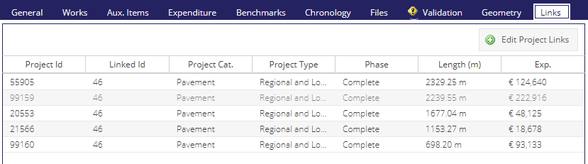
| User Story | #2.2 Linked Projects | |||
| Bug | Missing Title on 'Projects Group' Grid | |||
| Bug | Missing '?' link from the Form | |||
| Bug | Strip Map' button displaying for Project Groups | |||
| Bug | Confimation required to remove project from group | |||
| Bug | Project Group deleted when a new one is create while the Grid Entry is highlighted | |||
| Bug | Length (m) showing as non-rouded | |||
| Bug | Error displayed when saving specific Project | |||
| Bug | Point Selection not working if used after saving | |||
| Task | UI: Add 'Links' tab to Projects form | |||
| Task | UI: Create 'Create Project Group' and menu items | |||
| Task | UI: Create groups grid | |||
| Task | .NET: Create new services | |||
| Task | .Net: Create service to select projects by polygon | |||
| Task | DB: Create project.ProjectGroups | |||
| Task | Test 2.2 Linked Projects | |||
| Task | UI/Mapping: When a Project Group form is opened, render the included projects as WMS | |||
| Task | UI: Display Total Project Length and Total Project Expenditure in Project form Links tab | |||
| Task | Highlight project if already in group and give option on save | |||
| Task | Send error message to frontend if a selected project is already part of a group | |||
| Task | Create doc page and update links | |||
| User Story | #2.5 Layer Description data capture field | |||
| Bug | Id and Lane not displaying any information | |||
| Task | Frontend: add free text 'Description' field to project section grid (hidden by default) | |||
| Task | Mapping: Add new Description field to Material Export MapServer view & grid | |||
| Task | .NET: update POST/PUT and GET to add a description to worksSectionDetails | |||
| Task | DB: Add 'Description' field to [project].[WorksSectionDetails] | |||
| Task | DB: Add new Description field to Material Export view | |||
| Task | Test 2.5 Layer Description data capture field | |||
| Task | Update documentation | |||
| User Story | #2.6 Edit Layer Widths | |||
| Bug | Layer Width Not being Exported to Shapefile | |||
| Task | DB: Add width column to worksectionsdetails | |||
| Task | Front End | |||
| Task | .NET: Update project services to reflect db changes | |||
| Task | DB: Update current project width values | |||
| Task | Test 2.6 Edit Layer Widths | |||
| Task | Update documentation | |||
| Feature | 6.1 Tech Refresh | |||
| User Story | #6.0 Python 2->3 | |||
| Bug | Active Network Edges SP has bug | |||
| Bug | Unable to route between two segments | |||
| Bug | Weird Geometry when overlapping geomerty | |||
| Bug | Invalid Geometry when draging geometry over itself | |||
| Bug | Can't create closed loop with exiting edge | |||
| Bug | Alternative Error message being displayed when trying to overlap geometry | |||
| Bug | Digitizing tool not picking up on an edge if digitized in specific way | |||
| Task | Migrate export module | |||
| Task | Migrate mapping module | |||
| Task | Migrate segments module | |||
| Task | Migrate database module | |||
| Task | Migrate loader module | |||
| Task | Migrate solver module | |||
| Task | Migrate config module | |||
| Task | Migrate main web application module | |||
| Task | Migrate edge solver module | |||
| Task | Migrate point utils module | |||
| Task | Migrate classes module | |||
| Task | Create full test suite | |||
| Task | Update Azure Devops Deployment and Build Pipelines | |||
| Task | Create test coverage setup and stats | |||
| Task | Network rebuild services | |||
| Task | Create Sphinx documentation | |||
| Task | Setup Hypercorn and FastAPI | |||
| Task | Configure mypy and type checking | |||
| Task | Add zipped venv to deployment setup | |||
| Task | Check networks are recreated when a new version is created | |||
| Task | Test 6.0 Python 2->3 | |||
| Task | Switch UI to use new services | |||
| Task | Deploy Python 3.10 on Compass servers | |||
| Task | Deploy Python 3.10 on LGMA servers (including UAT) | |||
| Task | Test a staging deployment | |||
| User Story | #6.1 Upgrade of Mobile Apps to target later Android Versions | |||
| Bug | Projects App - Logout Failed to prompt user with logout warning "Are you Sure you want to log out ?" | |||
| Bug | PSCI App - Report To Us Failed - Files and Media Permissions to device prevents sharing attachments | |||
| Bug | PSCI App - Check for Updates Failed - App shows warning " No Internet Connection" when connected to the internet. | |||
| Bug | Works App Issue - PSCI survey values not visible Browser | |||
| Bug | Project app - Saving as draft after using soft back button | |||
| Task | Support Android 13 - PSCI | |||
| Task | Support Android 13 - Speed Limits | |||
| Task | Support Android 13 - Footways | |||
| Task | Footways - Check if CI/CD for Staging works | |||
| Task | Support Android 13 - Bridges | |||
| Task | Support Android 13 - Projects | |||
| Task | Regression Test Mobile Apps - staging | |||
| Feature | 6.1 Misc | |||
| User Story | #3.1 Missing Edges: Add a Files tab to the Missing Edges form | |||
| Task | Test 3.1 Missing Edges: Add a Files tab to the Missing Edges form | |||
| Task | UI: add File tab to missing edges form | |||
| Task | .NET: create attachment services | |||
| Task | Update documentation | |||
| User Story | #3.2 Segments: Usage Classification Updates | |||
| Task | Test 3.2 Missing Edges: Usage Classification Updates | |||
| Task | DB: Add new Usage Classifications of Busway & Bus Lane | |||
| Task | DB: check constraint, If IsBusway = True, usage classification must = Busway | |||
| Task | Frontend: If IsBusway checkbox is selected, auto-choose Busway usage classification | |||
| Task | Update documentation | |||
| User Story | #5.0 Modify all PMS Apps user privileges - remove web app access default | |||
| Task | Implement Privileges - PSCI | |||
| Task | Implement Privileges - Projects | |||
| Task | Implement Privileges - Speed Limits | |||
| Task | Implement Privileges - Footways | |||
| Task | Test 5.0 Modify all PMS Apps user privileges - Speed LImits App Regression Testing | |||
| Task | Implement new user roles for the Pms Authentication Service nuget package | |||
| Task | Implement Privileges - Bridges | |||
| Task | Footways app - deploy to Staging | |||
| Task | Projects app - deploy to Staging | |||
| Task | Bridges app - deploy to Staging | |||
| Task | PSCI app - deploy to Staging | |||
| Task | Speed Limits app - deploy to Staging | |||
| Task | Footways app - deploy to Production | |||
| Task | Projects app - deploy to Production | |||
| Task | Bridges app - deploy to Production | |||
| Task | PSCI app - deploy to Production | |||
| Task | Speed Limits app - deploy to Production | |||
| Task | Prepare source code for ESP (Footways, Projects, PSCI, Speed Limits, Footways) | |||
| Task | Test 5.0 Modify all PMS Apps user privileges - Bridges App Regression Testing | |||
| Task | Test 5.0 Modify all PMS Apps user privileges - remove web app access default | |||
| Task | Create new user roles for all mobile apps (except Bridges) and implement in management tool | |||
| Task | Update all external services used by old shared mobile role (Mobile_Upload) to use new roles | |||
| Task | Test 5.0 Modify all PMS Apps user privileges - Footways App Regression Testing | |||
| Task | Test 5.0 Modify all PMS Apps user privileges - PSCI App Regression Testing | |||
| Task | Test 5.0 Modify all PMS Apps user privileges - Projects App Regression Testing | |||
| User Story | #3.4 Add Is Proposed to Missing Edges form for Missing Edge Resolvers | |||
| Bug | Able to Access Edges 'Proposed' Layer and Grid without the Missing Edge Resolver Role Assigned | |||
| Task | Test 3.4 Add Is Proposed to Missing Edges form for Missing Edge Resolvers | |||
| Task | Frontend: IsProposed for Missing Edges | |||
| Task | BE: Update services and validations for IsProposed in missing edges | |||
| Task | DB: Add IsProposed to [network].[MissingEdges] | |||
| Task | Mapping: Create layer | |||
| Task | Update documentation | |||
| User Story | #3.3 Missing Edges: Filter for new styles in combined edges and network edges & nodes | |||
| Bug | Edge Status column not filtering (always filtering to blank) | |||
| Bug | Node Connectivity Legend and Style not working Correctly | |||
| Bug | When filtered for Connected the Map will still display Floating entries | |||
| Bug | When Filtering for Missing Edge the map is displaying System Generated icon | |||
| Bug | Naming in Filter and in Layer Legend has different Terminology | |||
| Bug | Missing Option in filter to filter by 'Unimported' | |||
| Task | Test 3.3 Missing Edges: Filter for new styles in combined edges and network edges & nodes | |||
| Task | Update mapfiles | |||
| Task | Update jsons | |||
| Task | Update views | |||
| User Story | #4.0 List all PMS users in the National admin panel | |||
| Bug | For some Apps the Entry only updates if synced, not on login | |||
| Task | Refactor management tool to allow editing users by Id | |||
| Task | Upgrade PMS solution to use latest Compass base packages | |||
| Task | Modify authentication service and related user db table to allow saving of login source | |||
| Task | Implement users Excel template, Excel generator and export functionality in management tool | |||
| Task | Implement users grid with new columns in management tool | |||
| Task | Visual improvements to System Users grid in management tool on national site | |||
| Task | Refactor and improve user/user roles/login source validations in authentication service | |||
| Task | Implement login source for authentication service in Web UI | |||
| Task | UI: Align layout | |||
| Task | Test 4.0 List all PMS users in the National admin panel | |||
| Feature | 6.1 UAT Feedback Release 1 | |||
| User Story | Ref 01: Unable to view programmes | |||
| User Story | Ref 02: Unable to open project form from Project grid. | |||
| User Story | Ref 03: Filtering RS layer by LA | |||
| User Story | Ref 04: Filtering Projects layer by LA | |||
| User Story | Ref 05: No Information Tool | |||
| User Story | Ref 06: Filtering MD’s | |||
| User Story | Ref 07: Gazetteer not working | |||
| User Story | Ref 08: Material Report Not Available | |||
| User Story | Ref 09: Unable to load townlands grid | |||
| User Story | Ref 10: Unable to load project start end points grid | |||
| User Story | Ref 11: Road Labels | |||
| User Story | Ref 12: ATI Features (Schedule Information) not available to new user role. | |||
| User Story | Ref 13: ATI Features Footway | |||
| Task | Add Is On Footway? | |||
| User Story | Ref 14: Column Filters | |||
| Feature | 6.1 UAT Feedback Items Release 2 | |||
| User Story | Ref 01: Abandoned before Extinguished | |||
| Bug | Extinguished Segment will not change to the correct Style when Extinguished | |||
| Bug | When a Public RoW exists on a Non-Public Road, users should be able to Extinguish without Abandoning first | |||
| Bug | Extinguishing is not updating the right of way from public | |||
| Task | FE: Is Extinguished greyed out by default | |||
| Task | BE: Update validations in the backend | |||
| User Story | Ref 02: Do not include abandoned in Schedule Length | |||
| Bug | Currently possible to have a Road Segment that is Abandoned and Include in Schedule simultaneously | |||
| Bug | Small typo in the include in Schedule Warning | |||
| Task | Replace confirm prompt with show prompt and default to cancel button | |||
| Task | FE: Reword waring for include in schedule | |||
| User Story | Ref 03: Grey-out admin fields DevOps Ref: 1.4a | |||
| Task | FE: Grey out fields when Is Abandoned | |||
| User Story | Ref 04: NULL ToW and Status DevOps Ref: 1.4a | |||
| User Story | Ref 05: Agreement Ceased Logic DevOps Ref: 1.4a | |||
| Bug | Agreement Ceased? Flag not being set when the user Ticks 'Agreement Ceased?' | |||
| Task | If Agreement Ceased is selected, default Type of Way to 'Private' (editable) | |||
| User Story | Ref 06: Move Admin box DevOps Ref: 1.4a | |||
| Task | FE: Update UI | |||
| User Story | Ref 07: Delete Admin and legacy values tab | |||
| Task | FE: Remove tab | |||
| Task | FE: Don't POST values | |||
| Task | BE: Update POST/PUT/GET | |||
| Task | FE: Completely remove the 'Legacy' tab from the form | |||
| User Story | Ref 08: Greenway Style Option | |||
| User Story | Ref 09: Unit for meters | |||
| Task | Update UI | |||
| User Story | Ref 10: Updating grids that reference the schedule | |||
| Bug | Linked Segment?' column is available in all Latest Survey Grids | |||
| Bug | Double Clicking a width survey in the grid not opening the Form | |||
| Bug | Road Category filter missing the 'U' entry | |||
| Task | Investigate | |||
| Task | DB/BE: Update Views & Services for Segment level data in Survey Modules | |||
| Task | FE: Add new fields to Pms.util.SegmentsGrid | |||
| Task | Mapping: Update "Latest" grids with new columns | |||
| Task | DB: Add fields to [roadschedule].[Segments_CutWithPolygon] & [roadschedule].[Segments_Solver] | |||
| User Story | Ref 11: Style ‘Owner’. | |||
| Task | Mapping: Update text | |||
| User Story | Ref 12: Consistent Language | |||
| Task | FE: Update field name | |||
| User Story | Ref 13: Validations for costs not matching | |||
| Bug | Validation is only triggered if the Field is highlighted after changing value for Aux Items | |||
| Task | FE: Investigate | |||
| Task | FE: Validate values and display red warning | |||
| User Story | Ref 14: Group Name in Project Layer DevOps Ref: 2.2 | |||
| Task | Mapping: Update view & grid | |||
| User Story | Ref 15: Add fields to Group Grid DevOps Ref: 2.2 | |||
| Bug | Majority Funding Source filter to have list | |||
| Task | BE: Update service(s) | |||
| Task | FE: Update grid with new values from service | |||
| Task | DB: Investigate | |||
| User Story | Ref 16: Scale of features | |||
| Bug | remove grouping highlight from aux features | |||
| Task | FE: investigate | |||
| Task | Mapping: Use strokes | |||
| User Story | Ref 17: User Input Width Validation | |||
| Bug | Validation can be circumvented by filling in values and deleting them Afterwards | |||
| Bug | Width not Being Enable for 'Treatment Course' and 'Geosynthetics' layer | |||
| Task | FE: Don't add default width until Mat Des thickness/chipsize is added first | |||
| User Story | Ref 18: Reorder of fields in Exp Tab | |||
| Bug | Project Expenditure' to be Renamed to 'Expenditure' | |||
| Task | FE: Update UI | |||
| User Story | Ref 19: Add project by default | |||
| Bug | Create/Edit Project Links Won't pick up on Group created | |||
| Task | FE: When a new group is created from a project form, add that project to the group by default | |||
| Task | BE: Get project's group data by ProjectId | |||
| Task | FE: Update button text in project links tab Create/Edit Project Links | |||
| User Story | Ref 20: Aux Style Options | |||
| Task | Mapping; add style | |||
| User Story | Ref 21: Aux ID displaying before save | |||
| Task | FE: Don't display temp id in Aux Form, leave bank until created in the db | |||
| User Story | Ref 22: User Input Validation | |||
| Bug | Length is kept when the 'Clear Record' functionality is used | |||
| Task | FE: Dont populate Length for section layers by default | |||
| Task | DB: Update Material Export view | |||
| User Story | Ref 23: Layer description view option | |||
| Bug | Show Layer Description Functionality only working for the first Section if the form is saved will View option is On | |||
| Task | FE: Add new view option for Show Description | |||
| User Story | Ref 24: Project Points Label's | |||
| Task | Mapping: Update Labels | |||
| User Story | Ref 25: Aux Item has files | |||
| Task | DB/BE: Update view and GET service | |||
| Task | FE: Add new column to gird | |||
| Task | Mapping: Add HasFiles to Aux Items layer grid | |||
| User Story | Ref 26: How is width calculated? | |||
| Task | BE: Calculate % coverage of latest width surveys per segment and add to service. | |||
| Task | FE: Add new column to the segment measurements panel | |||
| User Story | Ref 27: Incomplete has no End Date (Yet) | |||
| Task | BE: Update logic | |||
| User Story | Ref 28: Incomplete has no Actual Cost (Yet) | |||
| Task | BE: Update logic | |||
| User Story | Ref 28: Incomplete cannot Lock | |||
| Task | BE: Investigate | |||
| Task | BE: Update Logic | |||
| User Story | Ref 28: National User extract missing users | |||
| Task | BE: Update formatting | |||
| User Story | Ref 18: Add new fields to project grid DevOps Ref: 2.1 | |||
| Bug | No. Linked Project(s)' counting differently depending on if the Project is the only one in the Group or Not | |||
| Bug | Material Costs not Adding up for Some Projects | |||
| Bug | Auxiliary Item(s) Cost (€)' and 'Material Costs (€)' columns missing from the La Grid | |||
| Bug | Some Fields not filtering by '0' | |||
| Feature | 6.1 Regression | |||
| User Story | Works Grid | |||
| Bug | If the user inputs new Aux. Item with Cost > Actual cost, frontend validation is only triggered when user changes to the expenditure Tab | |||
| Bug | Width can't be edited after save | |||
| Bug | User Able to Edit the Width for Surface Course | |||
| Bug | Works Grid Stops Working | |||
| User Story | Bridges Module | |||
| Bug | Bridge Culvert not Being Displayed in Blue | |||
| User Story | ATI data capture module | |||
| Bug | Calculated Length not finding exact match | |||
| Bug | Lock Column displaying with an Empty icon/No text | |||
| Bug | Feature displaying for User not associated with the Road Schedule Editor role | |||
| Bug | Last Updated filters not Working | |||
| User Story | Width Survey | |||
| Bug | Width Survey Edges - Exported Shape file displaying additional Summary Id column | |||
| Bug | Latest Width Survey - Exported Shape file displaying additional Summary Id column | |||
| User Story | AADT Module | |||
| Bug | AADT Survey not opening | |||
| User Story | Auxiliary Items | |||
| Bug | Auxiliary Item Grid timing out if filtered by specific values | |||
| Bug | Last Update filters not working | |||
| Bug | Changing Filters to List | |||
| User Story | Missing Edges Module | |||
| Bug | Inconsistency between the Layer Legend and Column Filter Options | |||
| User Story | NTA/TII User Privileges | |||
| Bug | NTA/TII user not able to open Programmes | |||
| Bug | Console Error when accessing Project Groups Grid | |||
| Bug | NTA/TII user able to Access the Add Group Form | |||
| Bug | Adding some columns will make Grid results blank when logged in as NTA or TII | |||
| Bug | NTA/TII can't access the Attached Thumbnails for Projects and Programmes | |||
| User Story | Missing Edges: Filter for new styles in combined edges and network edges & nodes | |||
| Bug | Node Connectivity filter not finding 'Floating:Unregistered' entries | |||
| User Story | Road Schedule processes (abandoned, extinguished, agreed consent to access | |||
| Bug | Can't assign the same Segment ID as existing Extinguished Segment |