PMS 5.2 Release Notes
Released 15/07/2021
The 5.2 release includes a new OSi road network with 2 years worth of updates, along with the addition of user entered edges.
The codebase has also been refactored to share common components with the RMO’s Public Lighting System. The benefits of sharing parts of the codebase allow features such as thumbnails and performance improvements to be brought directly into PMS.
The many JavaScript libraries have been updated to their latest versions, including the significant step of moving from OpenLayers 4 to OpenLayers 6.
Prime2 Updates
The Prime2 road network update involves 346,579 old edges from 2019 (including edges added from MapRoad and LAs) mapping to 343,267 new Prime2 edges, based on the March 2021 version of OSi’s Prime2. This is 2 years worth of network updates and changes.
278,167 of the current edges have associated data from up to 13 different datasets (segment codes, PSCI, speed limits etc.).
This round of Prime2 updates will add 461 Km of road network and a total of 4,024 edges.
Old edges that route to 1 or more new edges and have <5m of difference in length are automatically transferred. This leaves all roads that have been modified since 2019 to review, and in many cases the default route needs to be adjusted using configuration files and Python scripts.
Each LA is reviewed by one analyst and then a final review/check is carried out by a separate team member to provide an additional level of checks. The table below provides a breakdown of edges that required manual intervention to map to the new network.
Local Authority |
Old Edges |
Old to New |
Manual Overrides |
Node Updates |
New Prime2 Edges |
|---|---|---|---|---|---|
Carlow |
4,267 |
60 |
0 |
8 |
43 |
Cavan |
9,646 |
19 |
3 |
0 |
10 |
Clare |
11,790 |
105 |
3 |
20 |
55 |
Cork City |
10,283 |
66 |
6 |
22 |
144 |
Cork |
30,614 |
192 |
1 |
19 |
238 |
Donegal |
20,224 |
66 |
5 |
11 |
77 |
Dublin |
14,306 |
79 |
4 |
13 |
133 |
Dun Laoghaire - Rathdown |
8,187 |
91 |
3 |
12 |
170 |
Fingal |
12,596 |
181 |
71 |
25 |
521 |
Galway City |
3,924 |
29 |
2 |
3 |
33 |
Galway |
17,880 |
141 |
17 |
31 |
207 |
Kerry |
16,906 |
52 |
20 |
8 |
69 |
Kildare |
12,120 |
98 |
9 |
17 |
256 |
Kilkenny |
8,423 |
119 |
26 |
8 |
119 |
Laois |
6,677 |
25 |
13 |
6 |
63 |
Leitrim |
5,699 |
24 |
2 |
4 |
17 |
Limerick |
12,395 |
175 |
30 |
15 |
104 |
Longford |
4,868 |
37 |
14 |
1 |
18 |
Louth |
8,088 |
66 |
22 |
5 |
153 |
Mayo |
21,288 |
37 |
3 |
7 |
32 |
Meath |
13,201 |
120 |
11 |
15 |
409 |
Monaghan |
6,347 |
24 |
4 |
2 |
27 |
Offaly |
5,546 |
17 |
2 |
2 |
17 |
Roscommon |
11,680 |
83 |
15 |
7 |
21 |
Sligo |
9,086 |
36 |
8 |
2 |
5 |
South Dublin |
10,401 |
162 |
43 |
21 |
399 |
Tipperary |
14,263 |
251 |
30 |
2 |
43 |
Waterford |
9,138 |
89 |
17 |
9 |
117 |
Westmeath |
6,897 |
81 |
33 |
3 |
55 |
Wexford |
10,995 |
58 |
22 |
8 |
241 |
Wicklow |
8,844 |
122 |
21 |
8 |
224 |
New Layers
A number of new layers have been added to the new PMS UI, created during the Prime2 review process, and also as part of migrating all layers and functionality from the old UI to the new UI. These are:
Other Layers
Speed Ramps
Footways Condition Ratings
Base Layers
The Base Layers baselayer has been updated to use tiles from MapBox. This has a clearer and brighter style than the default OSM service which runs on servers supported by donations only.

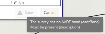
Validation Messages on Save Button
When the “Save” button is disabled due to fields on a form being incomplete, a warning triangle is displayed and when hovering over the button the missing field names are displayed in a tooltip. This should help users who are unaware of why they cannot save a record.
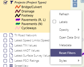
Reset Filters on Layer
The layer context menu (displayed when right-clicking on a layer) now contains a “Reset Filters” option to remove any filters directly without needed to open the associated grid.
Thumbnails Support
The 5.2 release includes support for displaying thumbnails of images associated with the following entities:
Roads Programmes
Speed Limits
Any associated files which are images will have a thumbnail displayed in the “Files” grid. Note the thumbnail is only displayed in the grid the next time the form is loaded, or when the “Refresh” button is pressed.
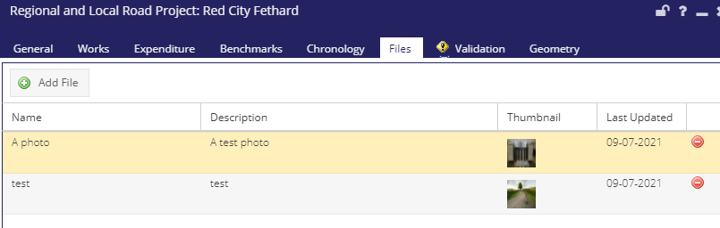
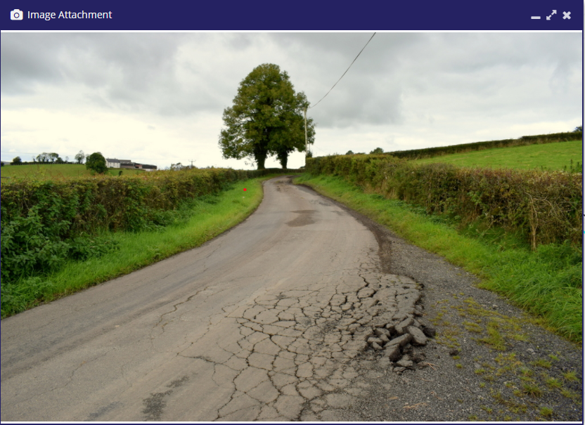
Double-clicking the record will open the full image in a new floating window, so it can be previewed without downloading. Clicking the image in the floating window will download a copy of the image.
If the file is not an image it will be downloaded directly when double-clicking on the grid (as previously).
Other Form Changes
A History tab has been added to the Speed Limits form, displaying all edits made to the limit
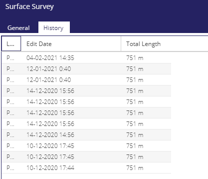
A History tab has been added to the Surface Survey form, displaying all edits made to the survey
MapServer Changes
MapServer has been reconfigured to use theAGG/PNG renderer when generating map images for all the layers in PMS.
In addition the following option was set - FORMATOPTION "QUANTIZE_FORCE=on".
This results in images that are visually identical but are much smaller in size (in some cases 3x smaller). This in turn will speed up loading of
map layers, especially for users on slower Internet connections. Download times reduced by between 20-50%.
The following sizes and download speeds were recorded when testing:
Layer Name |
PMS 5.1 Size |
PMS 5.2 Size |
PMS 5.1 Speed |
PMS 5.2 Speed |
|---|---|---|---|---|
Tipperary Road Schedule |
290 kB |
178 kB |
679 ms |
380 ms |
Latest PSCI Ratings |
656 kB |
200 kB |
1.46s |
1.37s |
Projects |
603 kB |
189 kB |
476 ms |
322 ms |
JS Dependency Updates
OpenLayers 4.6.5 to 6.5.4
GeoExt 3 to GeoExt 4
BasiGX from 2.1.0 to 3.1.0
Proj from 2.5.0 to 2.7.4
Sentry 5.29.2 to 6.8.0
Digitising Tool Updates
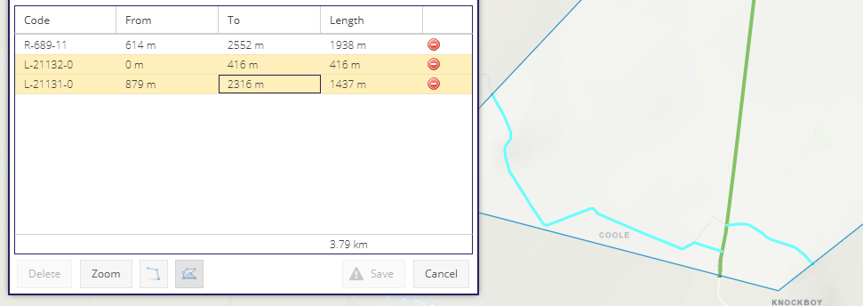
Additional functionality has been added to the feature selection tools used to create TINs, SEDs etc.
Multiple segments can now be selected in the grid and appear selected on the map:
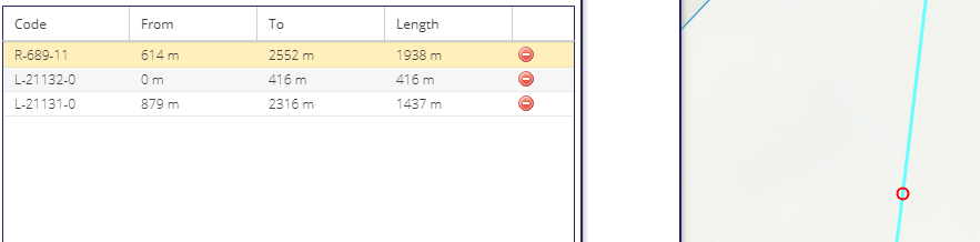
You can now click on a feature in the map to select it in the grid:
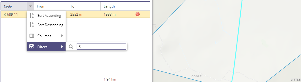
The features on the map are now also filtered whenever the grid is filtered:
Support Tickets
The following support tickets have been resolved in the 5.2 release.
Estimated Unit Cost not displaying on programme form https://support.maproadpms.ie/Ticket/1733
PSCI not displaying in project form https://support.maproadpms.ie/Ticket/1711
Construction method description https://support.maproadpms.ie/Ticket/1727