PMS 5.1 Release Notes
Released 16/04/2021
This release provides significant performance increases to the 5.0 release for map layers and grids. As there are new features and layers the version is set to 5.1 rather than a patch release number as it contains more than fixes to existing features.
New Features
MapRoadLicencing (MRL) Integration
Integration with the MapRoad Licensing system has been both enhanced and updated. The new services are both accessible via the Leaflet MRL Demo.
A new service has been created to allow data captured in PMS to be read into the MRL system to allow for automated granting of road opening license applications.
The existing WMS service currently used by MRL has also been updated to use the new TIN surveys data and Projects tables
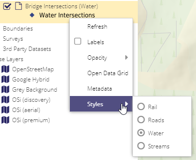
Bridges Layers
Bridges and Intersection layers have been added to the new UI. See the following links for details on each of the layers Bridges and Culverts, Bridge Polygons from OSi’s Prime2, and Bridge Intersections.
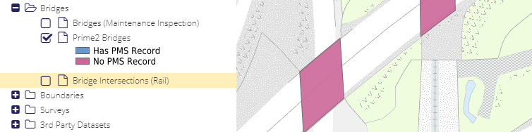
Each layer has an associated grid (right click and select “Open Data Grid”). Different Intersection types can be displayed
Bridges can now also be correctly exported and accessed via a WFS using different projections
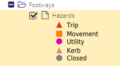
Footways Hazards Layer
The Footways - Hazards layer has been ported to the new UI (and is still available in the old UI).
Performance Enhancements
Significant performance improvements have been contributed to the MapServer project - the open source project used to serve all the map layers and grid data using WMS and WFS services.
Tests made using the same database copy, on the same database server.
Project Layer with Majority Funding Filter
This test was made with Projects and the Majority Funding Category filter set to “Restoration Improvement”. The grid Filter changed to use Funding Source Ids rather than a string, along with improvements to the MapServer core, so this is the case which has seen the greatest improvement.
Grid (loading 20 records):
5.0: 3.14 seconds
5.1: 0.42 seconds
Performance improved by a factor of 7
Map Layer:
5.0: Timed Out (over 60 seconds)
5.1: 0.64 seconds
Project Layer with Phase Filter
This test was for the Project layer with the Filter set to Complete.
Grid (loading 20 records):
5.0: 3.31 seconds
5.1: 0.35 seconds
Map Layer:
5.0: 12.75 seconds
5.1: 1.17 seconds
Performance improved by a factor of 10
Latest PSCI Ratings
The performance boost applies to any of the layers within PMS when a filter is applied.
Grid (loading 20 records):
5.0: 1.99 seconds
5.1: 1.19 seconds
Map Layer:
5.0: 13.42 seconds
5.1: 1.11 seconds
The updates provided to the MapServer project by Compass are linked to below:
Other Enhancements
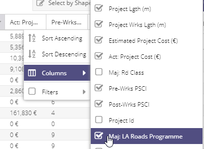
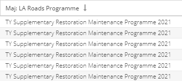
The Majority LA Programme Name is now available as a column in the Projects grid:
Phase Logic Updates
If a new Project has a funding source of a Submitted Programme added then its phase will remain in Planned until the Programme is manually resubmitted. This prevents new Projects automatically going straight to the Scheduled phase. A user will quickly be able to see that Planned (or Draft) programmes are in a LA Programme and know that they need to resubmit.
When checking for a valid PSCI survey, the 1st of January of the year of the Project Start Date is used. This avoids Projects having a valid survey at the time of creation, and then becoming invalid later in the year. For example:
a Project is created on the 1st of March 2021, and no start date is set. The system checked if a PSCI survey had been created between 01/01/2019 and 01/01/2021. A PSCI survey created on 01/05/2019 was found (for example), and the Project is deemed to have a valid PSCI survey.
a user later in the year sets the Start Date of the project to 01/06/2021. The system previously would then check for PSCI surveys between 01/06/2019 and 01/06/2021 and the PSCI survey of 01/05/2019 would now be outside this range and the Project would have no valid PSCI and could not be moved to the Complete phase.
With the update in 5.1 the system will search from 01/06/2021 back to 01/01/2019 (2 years from the year of the start date), and the 01/05/2019 PSCI survey will remain valid at the time of submission.
Once a Project is set to Complete by a user and locked, when Unlocked (by a user with Unlocker rights see Locking and Unlocking and User Roles), a new phase option “Not Completed” will be available. When this is set and saved, a user can then remove Funding Sources, save again, and finally delete the project if required. This allows invalid projects (mainly legacy Works created and imported as part of the 5.0 release) to be deleted. Previously this had to be done at the database level as the validation rules prevented a Complete project being saved if it had validation warnings, and it could not be deleted without removing Funding Sources. This option will only be accessible by administrators.
LA Programmes can now only be submitted if all associated Projects are in Planned or a later phase (no projects in Draft can be submitted). Do note however that as Phases are calculated by the system there is nothing preventing a user removing information that would change a Scheduled project back to Draft. A Project could also go back to Draft if the PSCI becomes invalid (out-of-date). The change to the logic for calculating when a PSCI survey becomes out-of-date will hopefully prevent most cases of this happening.
Documentation Updates
To take full advantage of the WFS services, and to ensure only the required data is downloaded (and avoid timeouts when trying to extract large national datasets), documentation on using filters in FME and MapInfo has been added - see GIS Connection Guides
Key Bug Fixes
When first submitting an LA Programme Projects were not automatically moving from the Planned to Scheduled phase. This has now been corrected.
The PSCI layer in the old/classic PMS has been fixed
An issue with the “Update” button being incorrectly disabled when editing a paving layer has now been corrected
Issues Resolved in this Release
Note as some issues contain multiple items, not all tickets are fully closed.
https://support.maproadpms.ie/Ticket/1707 - Bridges WFS - now works correctly
https://support.maproadpms.ie/Ticket/1705 - Railway Bridges - all intersections layers added
https://support.maproadpms.ie/Ticket/1691 - PSCI Layer not displaying in old MapRoad PMS
https://support.maproadpms.ie/Ticket/1694 - Access issue with Cork 2021 RI RWP (related to performance issues)
https://support.maproadpms.ie/Ticket/1699 - System Lag- Can’t open programmes in Cork Country (related to performance issues)
https://support.maproadpms.ie/Ticket/1709 - Unable to load layers from WFS in MapInfo 12.0 (related to MapInfo/WFS versions)
https://support.maproadpms.ie/Ticket/1695 - Is there an issue with the WFS for PMS? (related to MapInfo/WFS versions)
https://support.maproadpms.ie/Ticket/1696 - Works Form Issues PMS 5.0 (partially fixed - there are two unrelated issues here, the layer editing is fixed)
https://support.maproadpms.ie/Ticket/1702 - Phase Logic
https://support.maproadpms.ie/Ticket/1698 - Deletion of RM project (should now be possible with the “Not Completed” phase option)
https://support.maproadpms.ie/Ticket/1700 - Cannot delete Legacy projects marked as complete (should now be possible with the “Not Completed” phase option)
https://support.maproadpms.ie/Ticket/1711 - PSCI not displaying in project form
https://support.maproadpms.ie/Ticket/1715 - Majority road class displaying blank (includes filter fixes)
https://support.maproadpms.ie/ticket/1692 - Latest PSCI Layer Error