Network Edges
This layer displays the edges that are used to create road segments representing the Local Authority road schedule. These geometries are created and managed by OSi and are taken from the Prime2 GDF1 layer.
The Edges (Network) Layer is displayed in 2 different styles:
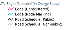
In Charge Status
Connectivity
A GDF1 is a notional line indicating the centreline of a Way or, in the case of a dual carriageway or motorway, the centreline of each carriageway.
Edges that are part of the road schedule are displayed in black, while uregistered and non-public are displayed in Mangenta and Grey. PMS includes editing tools to group edges into segments and to take edges “in-charge”.
In Charge Status
The In Charge Status Represents Edges depending on if they are Part of the Road Schedule
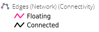
Connectivity
Similarly to Nodes, the connectivity Layer Style, displays Edges in Mangenta or Black depending on if they are Connected or Floating Edges.
Fields
Below are listed the fields associated with the dataset. Certain fields with database Ids are not listed below.
Type Name: The edge type in the OSi’s Prime2 data model e.g. Single Carriageway, Lane, Link Road etc.
Class Name: The edge class in the OSi’s Prime2 data model e.g. First Class down to Fifth Class. As Prime2 only stores line geometry up to fifth class, and edges that are part of an LA road schedule have a “(Managed)” postfix e.g. “Sixth Class (Managed)”
National Road Name: If the edge is part of a named national road then its name is found in this field e.g. R932. This value is maintained by the OSi
Street Name: Any street name associated with the edge. This value is maintained by the OSi.
Street Name Gaelic: Any street name in Irish associated with the edge. This value is maintained by the OSi.
In Charge: A value of 1 indicates it is part of the road schedule. 0 indicates it is not.
Note the vast majority of edges are taken from the OSi’s Prime2 dataset, however there are some edges that have been manually added as placeholders until added to Prime2.
Edges that have been added by LA users where roads are missing from the dataset. These have both “Type Name” and “Class Name” set to “User entered edge”
Edges that were present in the old MapRoad road schedules, but are currently missing in the Prime2 dataset during a review in 2019. These have both “Type Name” and “Class Name” set to “Imported from MapRoad”
Edges that were present in the old MapRoad road schedules, but are currently missing in the Prime2 dataset. These were added as part of a review in 2016. These have both “Type Name” and “Class Name” set to “Temporary MapRoad Edge”
Edges that were present in Prime2 but needed to be split as only part of the edge was part of the LA road schedule. This could be due to being split by an LA boundary, or because part of the road is private and part is public. These have a “Type Name” set to “Prime2 split edge”. The “Class Name” remains the same as in Prime2.
For reference: