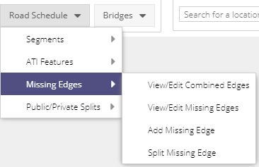
Missing Edges
Via the Road Schedule toolbar, users can access the Missing Edges grid and data entry form to add in roads that are missing from the road schedule. To add Missing Roads a user needs to be a part of the Road Schedule Editor group, and be logged in. Any user can view the list of Missing Roads in the system.
Missing Edges Layer
The Missing Roads WMS layer can be found under the Network Editing folder in the layer tree. The layer is styled as being:
Processed
Awaiting Processing
Right clicking the layer will produce a context menu where users can:
Open associated layer grid
Set the opacity
Turn on labels (including line direction)
Access layer Metadata

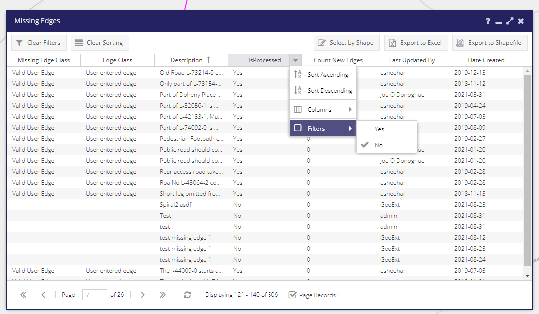
Missing Roads Grid
The Missing Roads grid is similar to the other grids in the system - records can be sorted and filtered. Filtering the grid will also filter the map. This grid can be filtered via three columns:
IsProcessed. Set to “No” only Missing Roads created following an update to the road network will appear. Missing Roads with Processed? set to “Yes” have already been added to the road network, and will function identically to any other road in the network (data can be assigned, they can be selected with the Info tool etc.). The Date Processed column indicates the date they were added to the road network.
Missing Edge Class
Edge Class
If the filter is cleared (with the “Clear Filter” button, or the sub-menu at the side of the Processed? column), all previously processed Missing Roads will be displayed.
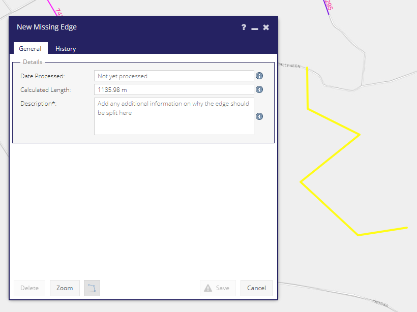
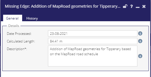
Missing Roads Form
To add a new Missing Road select “Add Missing Road” from the “Road Schedule” menu. This will open a form and give users access to the line tool. This allows a user to draw and save a line on the map representing a missing road.
When the geometry is updated the Calculated Length text box will be updated on the form. The Description field is required - please fill in as many details as possible about the road. This text can be sent to the OSi surveyors and aid them in recording the road. The Date Processed field will display Not yet processed until the Missing Road is added to the network as part of the offline processing.
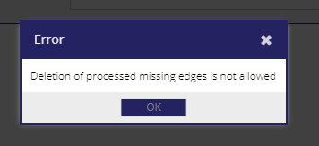
Deleting Missing Roads
If a Missing Road has not yet been processed, the record can be deleted by simply clicking the Delete button in that roads form.
If the Missing Road has already been processed, it is a part of the network and may have data associated with it. Clicking the Delete Road button will display the following message:
The deletion of the road has to be handled by the back-end process. To help find which roads should be deleted the Description field should be updated with the reason to delete the road (e.g. it no longer exists, it was added in error). To help find these roads it would be useful if the description also contained a keyword - it is suggested TODELETE is included to quickly find these.
Processed Missing Roads
Following the transfer of the road schedule from MapRoad to Prime2 a number of roads were missing in the Prime2 dataset. Many of the roads missing from Prime2 were added in manually following the transfer in a data entry exercise detailed on this Missing Roads summary page.
The Description fields for the roads can be edited by the user. The read-only Date Processed field displays the date the Missing Road was added to the road network.
Workflow
It is important to note that the Missing Roads tool does not add the new geometry to the road network directly. It is used to mark-up (or “red-line”) where an area of the road schedule is missing.
Roads are then reviewed in batches as part of an offline process. The latest OSi Prime2 dataset is reviewed to see if any of the Missing Roads are now present, and a new updated road network released as part of a PMS update.
The workflow steps can be summarised as follows:
A user identifies that a public road is missing from the road schedule. This typically occurs when they are trying to add a works or collect PSCI data for a particular road.
The user alerts a PMS Road Schedule Editor (if they do not have these permissions themselves).
The road schedule editor uses the Missing Roads tool to add a new geometry into the system, with a detailed description.
At a set frequency (yet to be confirmed) all missing roads are reviewed manually by the Road Management Office, and compared to the latest Prime2 road dataset provided by OSi. At this stage there are the following possible options for the Missing Road:
The missing road is present in the latest version of Prime2. This road will be brought in to the LA’s road network and appear in the PMS browser following an update.
The missing road is present in the latest version of Prime2, but only as a polygon feature. OSi are alerted that the road is part of the public road schedule, and will then create a centreline for the polygon and add the road as a “managed road”. This will then appear in a future release of Prime2.
The road is completely missing from Prime2. OSi are alerted to this, and will be sent the geometry and location of the road. This will be sent to their field survey team to correctly survey and digitise the road ready for a future release of Prime2.
In exceptional cases where a road is required against which to record critical works, the missing road may be added directly to the road schedule.
The user digitised geometry may be redrawn as part of this process based on aerial photography.
If the road is connected to another road then it is unlikely the road network will be split and a new junction created (this creates a significant overhead in terms of managing the Prime2 road network). It will simply “float” unattached on its own. It will still be possible to record data against the road, but it won’t be possible to route from the missing road to other parts of the network to create works (in this case multi-part works can be used).
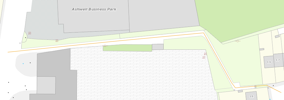
If a white polygon feature is present in the OSi Premium base layer, then it means there is a road polygon available in the latest version of Prime2 (the base mapping is updated automatically in PMS unlike the road network). An example is shown below:
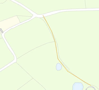
Below is an example of a road that is not in Prime2, and would need to be reported to the OSi:
Alterations to the national or regional road networks will be brought into Prime2 relatively quickly. In these cases there is no need to enter accurate geometry as this will be handled by the OSi. The Missing Roads tool should primarily be used to enter local public tertiary roads that may not have been surveyed by the OSi.
Adding New Estates
Currently only a single line feature can be created for a Missing Edge. This means a new estate would currently have to be digitised line by line with a record for each road. The main purpose of the tool is to alert the RMO and OSi there is a gap in the road schedule, rather than to capture detailed geometries, so in these cases a single road could be added with a a description noting there are many new roads comprising the estate.