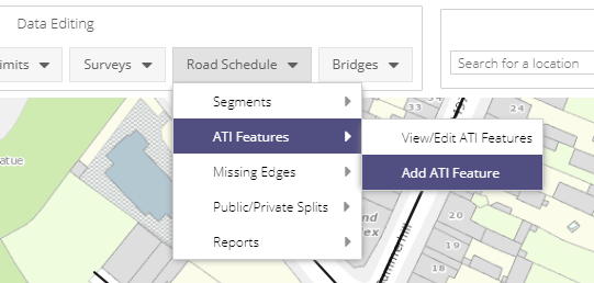
ATI Features
The ATI Features module is accessed from the Road Schedule dropdown of the Data Editing menu.
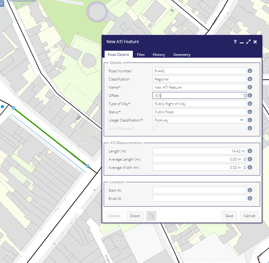
This module allows users to use linear referencing tools to mark scheduled parts of the road network as active travel infrastructure. For ATI that runs parallel to a roadway, users can reference the ATI element along the road centerline and then offset that line to create a visual representation of the ATI.
Grid & Layer
Any Segment that’s not a Roadway
All ATI Features
Usage Classifications
Displays ATI features divided by Usage Classification

Is Greenway
Displays ATI features divided by whether they are marked as Greenways or not

Road Details Tab
Road Number (Read Only): Use the linear referencing tool to select along the length of a road segments that share a Route Number. For example, you can select the R-445-1 and the R-445-2 under a single ATI Feature but not the R-445 and L-1223. If a user selects from segments over multiple Route Numbers then an error will get displayed:
All selected edges must matching values
Selected edge values:
R-445, Public Road, Public Right of Way
,
L-1223, Public Road, Public Right of Way
Classification (Read Only): Road class of the selected segments.
Name (Mandatory): The name of the ATI Feature being created.
Offset: Positive or negative values offset the selected geometry relative to the direction of the underlying edges.
Type of Way (Read Only): Type of way of the selected segment(s).
Status (Read Only): Status of the selected segment(s).
Usage Classification (Mandatory): ATI usage classification for the offset feature.
Is On Roadway: When the underlying segment is of usage classification Roadway and when a usage classification of Cycle Track is chosen, state if it is on the Roadway or not.
Is On Footway: When the underlying segment is of usage classification Footway, state if it is on the Footway or not.
Length: System calculated length of selected geometry.
Average Length: User entered length
Average Width: User entered width
Start At/End At: User entered description of the start and end points of the selected feature.
Files Tab
The Files tab of the ATI Feature form contains the ability to add reference files to the ATI Segment.
NOTE: Files can only be added after the Segment has been created.
History Tab
The History tab lists all edits made to the ATI Feature form from its creation onwards. The date of the edit and the logged in user who made the edits is displayed.
Geometry Tab
Details of the edges which make up the selected ATI Feature.
Grid Details
Column |
Visible/Hidden |
Usage |
Filter |
|---|---|---|---|
Usage Classification |
Visible |
One of : Cycle Track, Footway, Combined Footway Cycle Track |
List |
Class Code |
Visible |
Derived from segment |
List |
Road Number |
Visible |
Derived from segment |
Number |
Route Number |
Visible |
Derived from segment |
Text |
Name |
Visible |
Given name |
Text |
On Roadway? |
Visible |
For Cycle Tracks only |
Boolean |
Source |
Visible |
If the ATI Feature is from segments or offsets |
List |
Last Updated |
Hidden |
When feature was last updated |
Date |
Last Updated by |
Hidden |
Who performed the last update |
Text |
District/LEA |
Hidden |
Municipal District |
List |
Engineering Area |
Hidden |
Engineering Area |
List |
Engineering Area |
Hidden |
Engineering Area |
List |
ATID |
Hidden |
System Id |
Number |
Offset |
Hidden |
Offset in meters applied to the segment |
Number |
Main Class Code |
Hidden |
Derived from segment |
List |
Calculated Length |
Hidden |
Length of ATI Feature/Segment |
Number |
Measured Length |
Hidden |
User entered length |
Number |
Average Wdith |
Hidden |
User entered width |
Number |