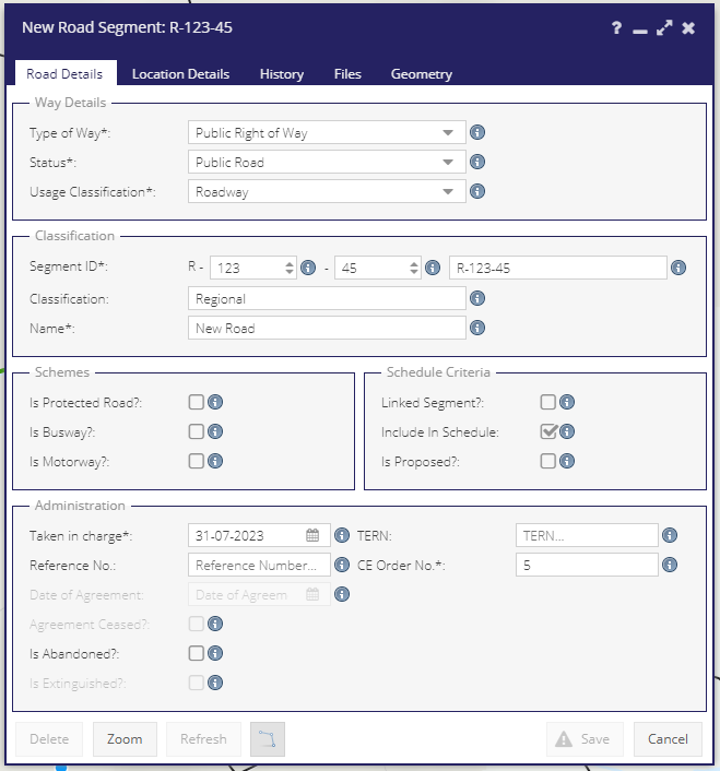
Segments - Road Details Tab
The Road Details tab of the Segments form contains general details about the Road Segment. It is comprised of 5 panels:
Way Details
Classification
Schemes
Schedule Criteria
Administration
There are mandatory fields that must be completed before the Segment details can be created, these are marked with an asterisk (*).
Some fields are calculated, some are user selected, and some are either user selected or calculated depending on values chosen elsewhere. For a more detailed presentation of how fields affect subsequent choices, see TABLE BLA
Way Details & Road Classification Logic
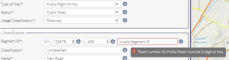
Users are encouraged to enter Way Details before they can create a Segment ID. This is due to the logic employed where, depending on if the registered segment is Public or Non-public, the Road Classification needs to be classified or unclassified.
If a user selects ‘Public Right of Way’ for Type Of Way, then they can choose ‘Public’ or ‘Non-public’ for Status. If ‘Non-public’ is selected, the Usage Classification will be automatically set to ‘Unclassified’ and will be read only. Thusly, the ‘Road Number’ section of the Segment ID must be formed of 6 digits. In this case the registered segment will get a ‘U’ prefix.
Conversely, in this scenario, if a user selects ‘Public’ for Status, the Usage Classification will be selectable and the ‘Road Number’ section of the Segment ID must be less than 6 digits.
Warnings are displayed to guide users towards the correct selections for each scenario.
Note
Way details are also effected by choices made under the Schemes and Administration panels.
Usage Classification
- Roadway: that portion of a road which is provided primarily for the use of vehicles (including pedal cyclists).
If any of Is Motoryway or Is Protected or Is Busway are checked, then Usage Classification defaults to Roadway and cannot be altered.
All segments entered prior to the release of 6.0, will default to Roadway.
Only segments tagged as Roadway will be downloaded to the mobile apps and used in PSCI calculations.
ATI Features can only be created from segments classified as ‘Roadway’
Automatic Classification
The Segment ID is made up of three elements:
Class code + Road Number + Segment Number.
The full Segment ID is determined by the amount and range of digits used for the Road Number. This happens as follows:
Range |
Digits |
Classification |
Code [*] |
|---|---|---|---|
<= 50 |
2 |
National Primary |
NP |
between 51 and 99 |
2 |
National Secondary |
NS |
between 100 and 999 |
3 |
Regional |
R |
between 1000 and 4999 |
4 |
Local Primary |
LP |
between 5000 and 9999 |
4 |
Local Secondary |
LS |
between 10000 and 99999 |
5 |
Local Tertiary |
LT |
between 100000 and 999999 |
6 |
Unclassified |
U |
Once the Segment ID is created the road is automatically assigned a Classification.
The ‘Name’ value is mandatory.
Any segment can be marked as proposed by checking the Is Proposed check box. In this case it will automatically be excluded from the schedule. If a user rechecks the Include In Schedule check box, a warning and a choice to proceed will be issued on saving the form.
Schemes & Schedule Criteria
Schemes
- Is Protected Road
A protected road means a public road or proposed public road specified to be a protected road in a protected road scheme approved by the Minister under section 49.
A Motorway or Busway can not be set as a Protected Road.
If Protected Road is Yes then Usage Classification can be Roadway only.
- Is Busway
A busway means a public road or proposed public road specified to be a busway in a busway scheme approved by the Minister under section 49.
A busway is intended as a special-purpose road for public transport vehicles while a bus lane is part of an ordinary road restricted for buses.
A Motorway or Protected Road can not be set as a Busway.
If Is Busway is Yes then Usage Classification is also changed to Busway
- Is Motorway
Any road classification besides Unclassified can be set as Is Motorway = true
When Is Motorway is checked the Segment ID prefix will change to M
A Busway or Protected Road can not be set as a Motorway.
If Is Motorway is Yes then Usage Classification can be Roadway only.
Schedule Criteria
- Include In Schedule
Yes, if Type of Way is Public Right of Way and Status is Public Road and Usage Classification is any of Roadway, Cycleway or Footpath.
On first creating a segment the system will expect the above specification to be met. If it is not, then a series of warnings are presented on the initial save of a Segment form.
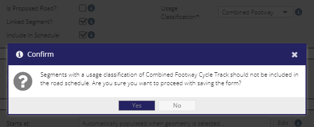
- Linked Segment
A Linked Segment refers to any infrastructure that is linked to a Roadway containing the same Road Number. This is a calculated field:
If Type of Way is Public Right of Way and Status is Public Road and Usage Classification is any of Cycle Track, Footway, Combined Footway Cycle Track, linked segment box is auto-checked by the system.
- Proposed Road
Select if the Segment forms part of a road that does not yet exist.
Administration
The Administration tab contains attribute information related to a Road Segment. The choices in this panel are general bound to options chosen elsewhere.
Taken in charge (date) and Chief Executive Order Number (CE Order No.) are required fields if Include In Schedule is checked.
TERN (Trans-European road network Reference Number) and (Taken in charge) Reference No. are not mandatory.
Date of Agreement is mandatory if the Type of Way is Agreed Consent to Access.
Agreement Ceased becomes selectable if the Type of Way is Agreed Consent to Access.
Is Abandoned? Public Roads can be abandoned. If a Public Road is abandoned it automatically becomes a Non-public road. Now the Public Right of Way can be extinguished.
Is Extinguished? A Public Right of Way can be extinguished. If a Road is a Public Road, it should be abandoned (and saved) before the Public Right of Way can be extinguished.
Mandatory fields for saving a new Segment form
Road Details Tab
Usage Classification
Type of Way
Status
Segment ID
Name
- If Include in Schedule is selected:
Taken in Charge
CE Order Number