Traffic Impact Numbers (TINs) Layers and Grids
TIN Surveys
The TIN Surveys Layer contains TIN surveys reperesented by Edges, representing the stretch of Road relevant to the Survey.
The TIN Surveys grid can be accessed by right clicking the TIN Surveys layer in the TIN Surveys folder of the Layer Tree and selecting Open Data Grid from the context menu.
Note
No geometries are displayed for the initial read-only LA-Wide Import of Segment Impact Codes TIN survey as this covers the whole road network. This is to avoid performance issues in the browser, and prevent hiding individual surveys. These surveys have a padlock icon in the top-right indicating they cannot be edited.
TIN Surveys
WMS/WFS layer name: TINSurveyEdges
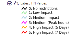
See TIN Values for categories.
TIN Survey Polygons
The TIN Survey polygon Layer contains TINs represented by Polygons, representing the area relevant for the curveyed feature
The TIN Survey Polygon grid can be accessed by right clicking the TIN Survey Polygon layer in the TIN Surveys folder of the Layer Tree and selecting Open Data Grid from the context menu.
TIN Survey Polygon
WMS/WFS layer name: TINSurveys
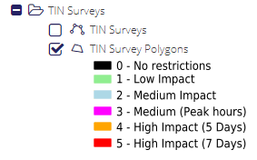
See TIN Values for categories.